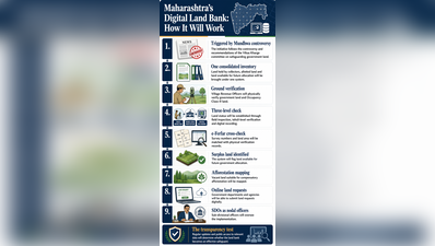
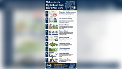
Pune: The state revenue department has launched a “land bank” module to build a unified digital inventory of govt land, current allotments and parcels available for future allocation in its bid to tighten safeguards after the Mundhwa land controversy.“The initiative follows recommendations made by the Vikas Kharge committee after the Mundhwa land row, which called for greater use of technology and stronger institutional safeguards in govt land management,” a senior official from the state settlement commissioner’s office told TOI on Tuesday.Developed under the state’s land dashboard, the platform will compile details of govt land held by district collectors, parcels allotted to departments and corporations, and vacant land that can be earmarked for projects or compensatory afforestation.Revenue officials said the initiative was designed to ensure that the location and status of a land parcel were clearly established before it entered the allotment process. “The system has been integrated with the e-Ferfar platform, enabling digital access to survey numbers, land area and other records, which will be cross-checked with the physical inspection reports before the status of the parcel is updated,” a revenue official said.To improve accuracy, the department has mandated physical verification, or ground truthing, of govt and occupancy class-II land. “Village revenue officers will inspect parcels on the ground, with findings verified by tehsildars before being uploaded to the land bank. This will give govt departments and agencies a consolidated picture before they seek land for projects,” the official said.Govt departments, corporations and autonomous bodies will also be able to apply for land online through the system. Sub-divisional officers have been designated as nodal authorities, with requests routed through field inspection, tehsil-level verification and digital processing.“The exercise is intended to go beyond simple digitisation by creating an updated and verified picture of govt land holdings. Once records are updated, the platform will identify land available for compensatory afforestation and future allocation,” a senior revenue department official said.The officials said the land bank was expected to improve transparency, create a clear audit trail and provide a single source of information on govt land. “Its effectiveness will, however, depend on timely updates, regular verification and the extent to which information is made accessible to the public. The emphasis is on accuracy as well as transparency. The field position will be checked and verified before the allocation status is recorded digitally,” another revenue official said.According to the officials, a centralised digital inventory can provide a stronger audit trail, but only if subsequent allotments, encroachments, changes in use and other alterations are regularly reflected in the system.